
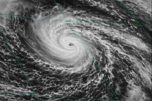
A nor’easter is named for the winds that blow in from the northeast and drive the storm up the east coast along the Gulf Stream, a band of warm water that lies off the Atlantic Coast. Known for dumping heavy amounts of rain and snow, producing hurricane-force winds, and creating high surfs that cause severe beach erosion and coastal flooding, a nor’easter can occur in the Eastern US any time between October and April.
There are two main components to a Nor’easter:
Gulf Stream Low-Pressure System: These counterclockwise winds generate off the coast of Florida. The air above the Gulf Stream warms and spawns a low-pressure system. This low circulates off the southeastern U.S. coast, gathering warm air and moisture from the Atlantic. Strong northeasterly winds at the leading edge of the storm pull it up the east coast.
Arctic High-Pressure System: As the strong northeasterly winds pull the storm up the east coast, it meets with cold, Arctic air blowing clockwise, down from Canada. When the two systems collide, the moisture and cold air produce a mix of precipitation.
Winter conditions make Nor’easters a normal occurrence, but only a handful actually gather the force and power to cause problems inland. The resulting precipitation depends on how close you are to the converging point of the two storms.
A powerful Nor’easter can bring travel to a standstill and they do occur frequently, but not all of them are newsworthy. There are two types of nor’easters:
Offshore Forming: These are the storms you hear about in the news. It is a news-worthy storm that moves east of east-coast cities, dumping lots of heavy snow. In an offshore-forming storm, the hardest hit metropolitan areas are likely to be Washington D.C, Philadelphia, New York City and Boston. Eventually, the system moves far enough north that the Canadian jet stream pushes it off the coast.
Onshore forming: These storms are less exciting than the offshore-forming storms. They move west of east-coast cities, with gusting winds and mostly rain.
Newsworthy Nor’easters
The Great Blizzard of 1888
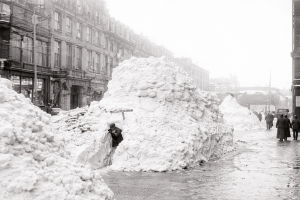
Occurring March 11 – March 14, 1888, the great blizzard of 1888 was one of the most severe recorded blizzards in the history of the United States. 40 – 50 inches of snowfall fell in parts of New Jersey, New York, Massachusetts, and Connecticut. 50 foot snowdrifts caused by sustained winds of more than 45 mph produced confined people to their homes for up to a week. 200 ships were sunk and more than 400 people died from the storm and the cold.
Ash Wednesday Storm of 1962
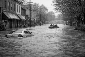
The storm of 1962 occurred March 6 – 8, 1962, along the mid-Atlantic coast of the United States. The impact o f this storm was extremely severe, lasting over a period of five high tides pounding coastal areas with continuous rain, high winds, and tidal surges, and dumping snow as far inland as Alabama and temperatures plunging to 32o across Florida. The storm killed 40 people and injured more than 1,000 more; thousands of homes and businesses were flooded with property damage across six states in the hundreds of millions of dollars.
The Northeastern United States Blizzard of 1978
The blizzard of 1978 formed on February 5, 1978 and broke up on February 7, 1978 after dumping over 27 inches of snow in Boston. One of the major problems with this nor’eater was the lack of foreknowledge about the storm’s severity and inaccurate weather forecasting had locals believing the storm was once again incorrect. Many people were left without heat, water, food, and electricity for over a week after the storm finished. About 10,000 people were forces to move into temporary emergency shelters and 54 people were killed. More than 3,500 cars were found abandoned and buried in the middle of roads and highways.
 The Perfect Storm 1991
This nor’easter developed off the coast of Canada on October 28, later combined with Hurricane Grace and eventually dissipated on November 4 after crossing over Prince Edward Island. In the middle of the storm, the Andrea Gail sank, killing its crew of six and inspiring the book, and later movie, The Perfect Storm. This storm began as a low pressure area that later became a powerful cyclone, gathering intensity form the remnants of Hurricane Grace; that the lashed the east coast of the US with high waves and coasting flooding before weakening. Traveling southwest over warmer water it developed into a subtropical cyclone, then a tropical storm, and then a full fledged hurricane once again. There were 13 deaths attributed to the storm (6 of which were the crew of the Andrea Gale) and caused over $200 million in damages.
The North American Blizzard of 1996
A severe snowstorm from January 6th – 8th, which brought up to 4 feet of snow to areas of the mid-Atlantic and northeastern U.S., and killed a total of 154 people.
 The North American Blizzard of 2003
This five day storm in February dropped over 2 feet of snow in several major cities, including Boston, and New York City, affected large areas of the Northeastern U.S., and killed a total of 27 people.
White Juan of 2004
The storm dropped heavy snowfall throughout the Nova Scotia peninsula and Prince Edward Island, with accumulations in the hardest-hit areas ranging from 20 to 39. This nor’easter occurred only 5 months after Hurricane Juan.
The North American Blizzard of 2010
A major nor’easter and historic blizzard affecting the United States from portions of northern Florida to Maine and portions of Canada on December 26–27, 2010. Portions of New Jersey received 34” of snowfall.
 The Halloween Nor’easter of 2011
This nor’easter storm became the 14th multibillion-dollar weather-related disaster of 2011. Across the Northeast, the combination of high winds and wet, heavy snow downed trees, most of which retained their leaves, and caused extensive damage. It formed early on October 29 along a cold front to the southeast of the Carolinas. As it moved up the East Coast, its associated snowfall broke records in at least 20 cities for total accumulations, resulting in a rare “white Halloween” two days later and caused 39 deaths.